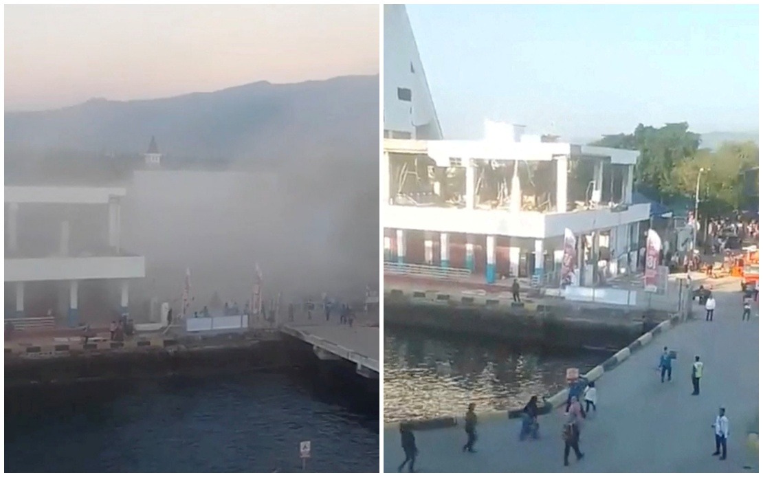
A devastating magnitude 7.7 earthquake that struck off the coast of Flores Island in eastern Indonesia on Saturday morning has claimed at least 20 lives, according to emergency officials coordinating rescue operations in the affected region. The seismic event, which was centred near Mbay town in Nagekeo Regency, has prompted a major humanitarian response and forced a comprehensive damage assessment across multiple districts in East Nusa Tenggara province. The initial tremor triggered several powerful aftershocks, compounding fears among residents and complicating rescue efforts as structural integrity of buildings remained uncertain throughout the day.
Official casualty figures released by the Maumere Search and Rescue Office indicate that alongside the 20 confirmed deaths, six people sustained injuries serious enough to require medical attention, while two individuals remain unaccounted for and feared trapped beneath rubble. These figures represent preliminary counts based on reports filtering in from affected communities, and emergency officials acknowledged that the full extent of human loss may not be immediately clear as teams continue systematic searches through damaged neighbourhoods and rural settlements. The variation between reported and confirmed casualties underscores the challenges rescue personnel face when operating in remote areas with limited infrastructure and communication networks.
Governor Melki Laka Lena of East Nusa Tenggara province provided updates at a press conference in Kupang, the provincial capital, describing a landscape of significant structural damage. Residential homes across multiple communities have been either partially or completely destroyed, while public buildings including government offices and schools sustained varying degrees of harm. Critical infrastructure including roads connecting isolated settlements has been compromised, with several major routes blocked by landslides triggered by the seismic activity. The governor cautioned that comprehensive damage assessment was still underway, as rescue teams had not yet reached all affected areas, particularly those in mountainous regions where access is naturally constrained.
Social media footage circulating widely across Indonesian and international platforms provided harrowing documentation of the earthquake's immediate impact. Video clips captured the moment structures collapsed into clouds of dust and rubble, while terrified residents fled into streets and open spaces seeking shelter from falling debris. The visceral nature of these recordings, combined with reports of survivors searching through wreckage for missing family members, underscored the human tragedy unfolding across Flores Island. These visual accounts prompted international concern and offers of assistance from regional neighbours, including Malaysia and Singapore, though formal requests for aid had not been formally processed at the time of initial reporting.
The earthquake's secondary effects proved almost as disruptive as the primary seismic event itself. Indonesia's Meteorology, Climatology and Geophysics Agency initially issued a tsunami warning following the offshore temblor, prompting coastal residents to evacuate to higher ground and authorities to halt maritime operations. This warning was subsequently lifted after careful analysis of ocean conditions and wave patterns, though the agency maintained urgent advisories cautioning the public against lowering vigilance. The possibility of substantial aftershocks remained a serious concern, as geological surveys indicated the subduction zone off Flores remained active and unstable, with additional tremors potentially exceeding magnitude 6.0 in the coming days and weeks.
Transport disruptions extended beyond the immediate disaster zone, affecting the broader East Nusa Tenggara region's connectivity with other parts of Indonesia. Multiple commercial flights serving the region, including those to and from international destinations, were cancelled as airline operators and aviation authorities implemented precautionary measures. This suspension of air services complicated efforts to deploy additional rescue personnel, medical supplies, and humanitarian assistance to affected communities. Airlines confirmed they would resume operations only once structural inspections of airport facilities were completed and seismic activity showed signs of stabilising.
Concern extended beyond Indonesia's borders as regional authorities issued advisories to their citizens. The Chinese Consulate General in Denpasar, responsible for Chinese nationals throughout a broad swath of eastern Indonesia, released a formal notice urging heightened vigilance among residents and tourists in the region. Particular attention was directed toward Chinese visitors in Labuan Bajo, a popular tourism destination on Flores Island that lies relatively close to the earthquake's epicentre. The consulate advised affected individuals to maintain close monitoring of official disaster warnings, remain prepared for potential tsunami waves despite the initial warning's cancellation, and maintain distance from coastal areas until geological stability could be conclusively determined.
The geographical characteristics of Flores Island have shaped both the severity of the disaster and the complexity of the response. Positioned along the Pacific Ring of Fire in a zone of considerable seismic activity, the island experiences frequent tremors of varying magnitudes, yet the magnitude 7.7 event represents a significant seismic occurrence with substantial destructive capacity. The island's mountainous terrain and limited road infrastructure meant that many communities remained isolated or difficult to access, hindering rescue operations and complicating the delivery of emergency supplies to survivors. These geographic constraints have long posed challenges for disaster management in eastern Indonesia, where remoteness has historically delayed comprehensive damage assessments and humanitarian relief efforts.
Regional implications of the Flores earthquake extend beyond immediate disaster response considerations. For Southeast Asia more broadly, the event serves as a sharp reminder of the region's pronounced vulnerability to seismic hazards and the critical importance of maintaining robust early warning systems and disaster preparedness frameworks. Malaysia, similarly positioned in an active geological zone, continues to refine its own earthquake monitoring capabilities and emergency response protocols informed by disasters that periodically afflict its neighbours. The Flores event has prompted regional cooperation discussions regarding shared early warning technologies and coordinated humanitarian assistance mechanisms for future major disasters affecting multiple countries or border regions.
Indonesian authorities ramped up search and rescue operations throughout Saturday and into subsequent days, mobilising personnel from military units, civil defence forces, and trained disaster response teams. The Indonesian National Disaster Management Authority coordinated efforts across multiple agencies, establishing emergency command centres and prioritising access routes to the most severely affected communities. As darkness fell on Saturday evening, search teams worked through the night utilising portable lighting and rescue equipment, racing against time to locate survivors and recover remains before weather conditions potentially deteriorated. Officials emphasised that the window for discovering survivors trapped beneath rubble typically narrows significantly after the first 72 hours, lending urgency to all recovery operations.