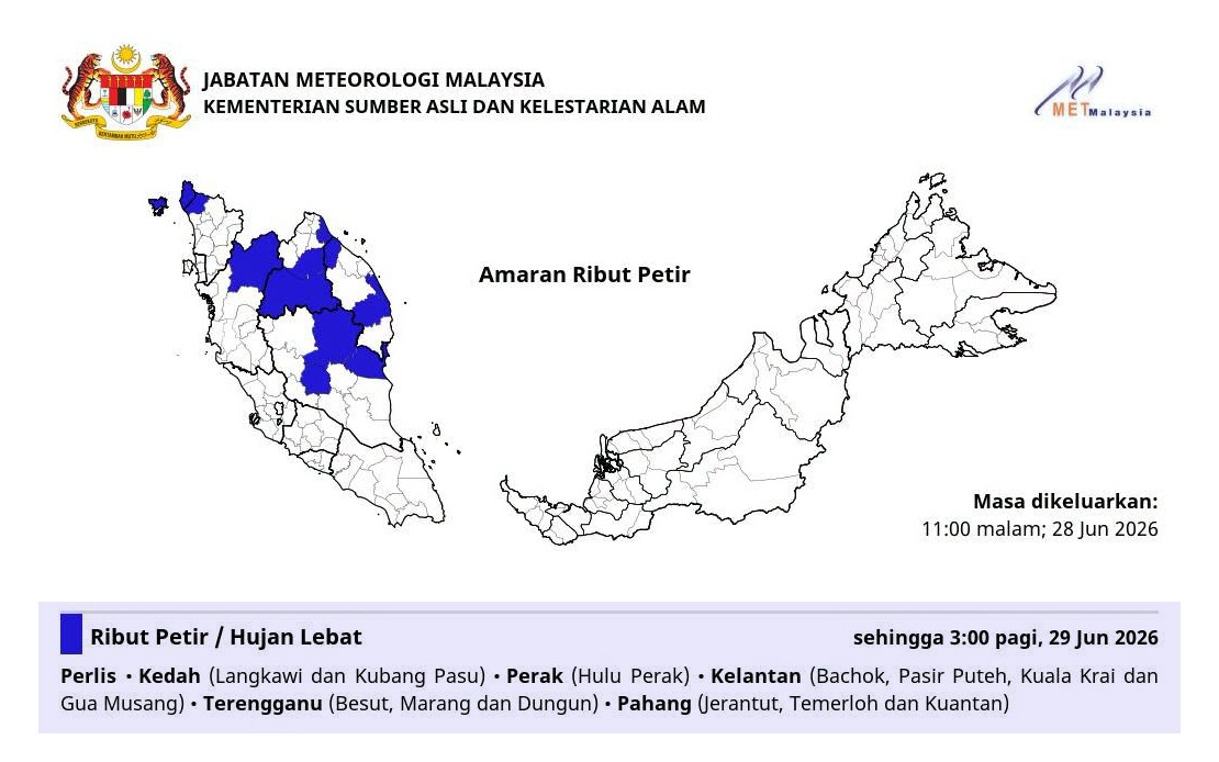
Malaysia's Meteorological Department has put six states on alert for severe thunderstorms, heavy rain and strong winds extending into the early hours of Friday morning, with the warning remaining in effect until 3 am. The alert encompasses multiple districts across the northern and eastern regions of Peninsular Malaysia, affecting an extensive stretch of the country's landscape and potentially impacting millions of residents and commuters during the overnight period.
The northern states of Perlis and Kedah face the brunt of the predicted severe weather, with MetMalaysia specifically naming Langkawi and Kubang Pasu in Kedah as particularly vulnerable areas. Perlis, Malaysia's smallest state, lies directly in the path of the weather system. Given Langkawi's status as a major tourist destination and Kubang Pasu's position in Kedah's population centre, the warning carries implications for both tourism and daily economic activities across these regions.
In Perak, the focus of concern centres on Hulu Perak, the state's interior highland region known for its challenging topography. Heavy rainfall in this area raises the prospect of landslides and flash flooding in low-lying settlements, given the region's susceptibility to water-related hazards during intense precipitation events. Residents in this district are advised to exercise heightened caution and prepare for potential disruptions.
The east coast states face equally significant threats. In Kelantan, four districts have been singled out: Bachok, Pasir Puteh, Kuala Krai and Gua Musang. Gua Musang, particularly, sits in a mountainous zone where heavy downpours can trigger rapid watercourse flooding. These districts' vulnerability to monsoon-influenced weather patterns makes them recurring focal points during Malaysia's monsoon seasons, though thunderstorm warnings can occur year-round during transitional periods.
Terengganu's coastal and interior districts of Besut, Marang and Dungun have also been flagged by meteorologists. These areas, positioned along the east coast, frequently experience intense convective activity during moisture-laden wind patterns. Marang's status as a fishing and agricultural hub means disruptions could affect livelihoods across multiple economic sectors, while Dungun's industrial and residential development adds to the potential impact radius.
Pahang, Malaysia's largest state by area, sees the warning apply to three districts: Jerantut, Temerloh and Kuantan. Kuantan, as Pahang's administrative capital and a major industrial and port city, represents a significant population centre where weather disruptions ripple through economic and social life. Temerloh, positioned along the Pahang River, carries particular flood risk given its riverine geography. Jerantut, situated inland and in a less urbanised setting, nonetheless serves as a gateway to Taman Negara National Park and rural communities.
The temporal specificity of the warning—extending until 3 am—suggests a concentrated weather system moving through the region rather than an extended period of instability. This timing falls during the late evening and early morning hours when visibility is lowest and emergency response capacity may be constrained. Late-night travellers on Malaysia's highway network, particularly the East Coast Expressway and northern routes connecting these states, should exercise extreme caution given reduced visibility during thunderstorms.
The combination of three meteorological hazards—thunderstorms, heavy rain and strong winds—creates a compound risk profile. Thunderstorms generate sudden violent winds capable of downing trees and causing structural damage. Heavy precipitation within short timeframes overwhelms drainage infrastructure, particularly in urban areas with inadequate stormwater systems. Strong winds accompanying tropical thunderstorms present hazards to vehicles, outdoor structures and overhead utilities. Combined, these elements warrant public vigilance and preparedness.
MetMalaysia's issuance of such warnings reflects the department's commitment to public safety during volatile weather episodes. The specificity in naming affected districts enables local authorities and residents to target preparation efforts appropriately rather than responding to state-level generalizations. Emergency management agencies across these states typically activate contingency protocols upon receiving such alerts, positioning rescue and relief personnel in anticipated high-risk zones.
Residents across the affected areas are advised to avoid unnecessary travel during the warning period, secure outdoor items that could become windborne projectiles, and remain alert to potential flooding in low-lying areas. Those in hillside communities should monitor conditions closely for signs of slope instability. Boaters and fishermen operating from coastal districts should seek shelter and avoid venturing into open waters where sudden weather deterioration could prove life-threatening.
The geographic distribution of this warning underscores how Malaysia's tropical monsoon climate can generate simultaneous severe weather events across multiple states, particularly during transitional seasonal periods. The east coast's exposure to moisture-laden winds from the South China Sea and the atmospheric dynamics over the peninsula's interior mountainous zones create conditions favouring rapid thunderstorm development and intensification. Understanding these patterns helps communities prepare proactively for recurrent seasonal hazards.
As the region heads into the overnight hours, residents should maintain awareness of weather updates from MetMalaysia and local meteorological bulletins. The relatively compressed timeframe of this warning means conditions should normalize by early morning, allowing resumption of normal activities by daylight hours, though localized flooding and damage assessments may extend beyond the warning period itself.