Arsenio Butil Jr., a fisherman and pastor in Sarangani province's Glan municipality, will never forget the moment last week when the ground beneath his home on Mindanao's coast began to convulse. As the 7.8-magnitude earthquake rocked the southern Philippine island, Butil Jr. fell to his knees in prayer. But when he rose and looked toward the shoreline he had known all his life, the landscape had begun its violent transformation. The ocean itself seemed to be retreating, revealing vast stretches of coral that had lain submerged for centuries, now thrust violently above the waterline as if by the hand of some geological giant.
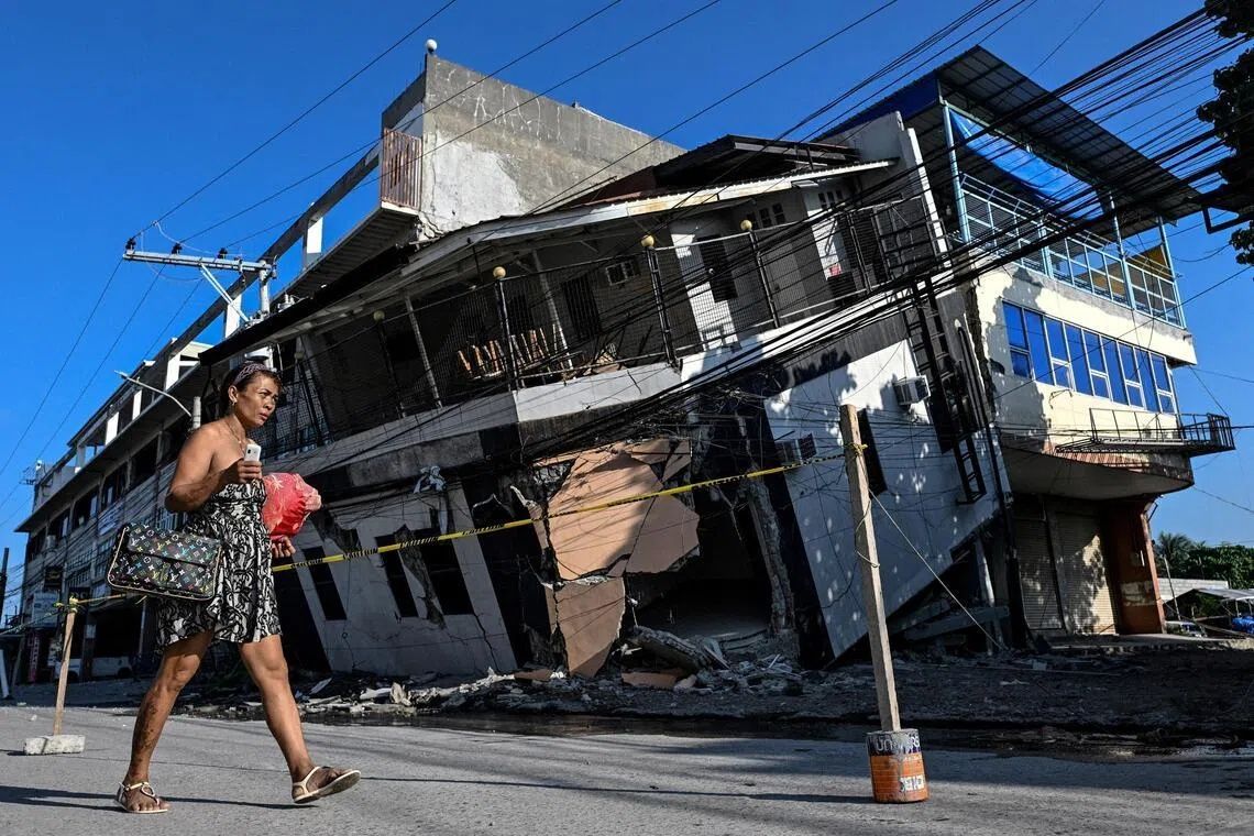
The June 8 earthquake, triggered by tectonic movements along the nearby Cotabato Trench, unleashed far more than just the immediate devastation typical of major seismic events. While it toppled buildings, triggered deadly landslides across the rugged terrain, and claimed the lives of at least 76 people across Mindanao, its most visible and enduring impact has been something more profound: the permanent alteration of the island's geography. The tectonic forces that unleashed this destruction also engaged in a process geologists call coastal uplift, a phenomenon whereby sections of the earth's crust are thrust vertically upward during an earthquake, extending the shoreline seaward and leaving behind a landscape utterly unrecognisable to those who have inhabited it for generations.
The physical evidence of this transformation is stark and unsettling. When journalists visited the affected area, they encountered fishing vessels that had once bobbed at the water's edge now stranded on the far side of towering walls of jagged, lifeless coral that stretched unbroken for kilometres in both directions. The sight represents more than an inconvenience; it symbolises the complete disruption of a way of life perfected over centuries. Butil Jr. recounted the surreal experience of watching the ocean withdraw and advance repeatedly during the initial quake. The water receded at least three or four times, he said, each cycle bringing a sense of dread that seemed to defy rational explanation. Dead fish floated in the shallow, churning waters as the earthquake forced the seabed itself into new positions.
The Cotabato Trench, situated as near as 50 kilometres offshore from Mindanao's coast, represents one of the most geologically active zones in Southeast Asia. Seismic activity here is not exceptional but rather the norm, with the region experiencing frequent tremors and, as recently as January, a dramatic seismic swarm comprising thousands of smaller earthquakes. Warning signals about the potential for a major event had circulated among international disaster risk reduction experts. A United Nations report released in mid-May had specifically flagged the seismic activity observed in the trench as a possible precursor to a significant earthquake—a warning that proved prescient and tragic.
According to Nane Danlag, a geologist at the Philippine Institute of Volcanology and Seismology, the changes residents are witnessing are permanent and measurable. The seabed rose approximately two metres during the earthquake, with initial assessments indicating that the coastline has extended by roughly 200 metres in some locations. Danlag explained that the affected area stretches across nearly 100 kilometres between two towns, making this one of the most significant coastal uplift events recorded in the region in recent decades. She emphasised that while the changes appear shocking to residents accustomed to stable geography, the process itself is entirely natural and has been occurring in this region for thousands of years, driven by the inexorable movements of the earth's crust along the subduction zone.
The human cost of this geological transformation extends far beyond the 76 confirmed deaths. About 100 people from a neighbouring village—fishermen and their families—remain encamped in the hills above their former homes, having fled to higher ground when the earthquake struck. Datu Atom Malimpnig, a Maguindanaon community leader, explained the psychological dimension of the disaster. The newly exposed coastline has created a profound sense of vulnerability and fear among the evacuees, many of whom remain convinced that a tsunami could yet materialise from the transformed seascape. The prospect of returning to homes that have been destroyed, sitting on ground fractured by powerful seismic forces, feels to many like a step toward disaster rather than recovery.
The economic implications extend to tourism and commerce as well. Edzel Baylon, a staff member at the Isla Jardin del Mar resort located in the affected region, articulated the commercial devastation wrought by the coastal changes. The resort's primary appeal had been its pristine white sand beaches and access to deep, clear waters suitable for swimming and water sports. Today, that same beachfront is separated from the ocean by a wall of exposed, jagged coral, rendering the shallow waters unsuitable for the recreational activities that generated the resort's income. What was once a picturesque tropical destination has become a geological curiosity, but one that offers little economic value to those whose livelihoods depended on its appeal.
The seismic activity has shown no signs of abating since the initial shock. The Philippine Institute of Volcanology and Seismology has recorded more than 8,500 aftershocks in the region since June 8, a staggering number that illustrates the profound instability of the earth's crust in this area. Each tremor, even those measuring below magnitude six, serves as a terrifying reminder to displaced residents that the ground beneath them remains restless and unpredictable. Butil Jr. has observed extensive cracking in the ground throughout Glan and surrounding areas, fissures that stretch for considerable distances and suggest that the underlying geology remains compromised. He and others fear that another earthquake of similar magnitude could strike with little warning, potentially causing additional destruction and loss of life.
The challenge facing authorities and communities is therefore multifaceted and daunting. Rebuilding homes and infrastructure presents only the most obvious hurdle; restoring confidence in the stability of the affected areas presents a far more profound psychological and social challenge. The geological reality—that this region sits atop one of the earth's most active plate boundaries—cannot be altered by human intervention. Communities must instead adapt to a landscape that has been permanently rewritten by forces beyond human control, while living with the knowledge that further transformation could occur at any moment. The June 8 earthquake has thus become not merely a historical event to be recovered from, but a reminder of the precarious relationship between human habitation and the dynamic processes that continuously reshape the earth's surface.
For Southeast Asia more broadly, the Mindanao earthquake and its aftermath offer important lessons about disaster preparedness and community resilience in tectonically active regions. The Philippines, Indonesia, and other nations throughout the region must grapple with how to develop infrastructure, urban planning, and emergency response systems that account for the possibility of major earthquakes and the permanent geographical changes they can produce. The experiences of fishermen like Butil Jr. and the families now living in hillside encampments provide sobering real-world case studies of how geological events can fundamentally disrupt entire communities and economic systems. As climate change adds additional pressures to coastal regions worldwide, the need for adaptive, flexible approaches to coastal development in seismically active areas becomes ever more pressing.